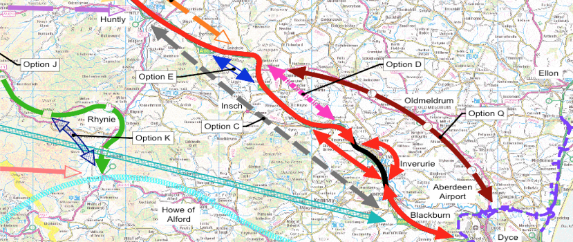
Alternative Routes
April 2017 - Updated Map Showing Alternative Routes.
The following map shows the updated alternative route options from Transport Scotland.
May 2015 - Transport Scotland - Extract from DMRB Stage 1 Assessment Report.
The following information is an extract from the "DMRB Stage 1 Assessment Report" from Transport Scotland (May 2015) regarding the different alternative routes that are being considered.
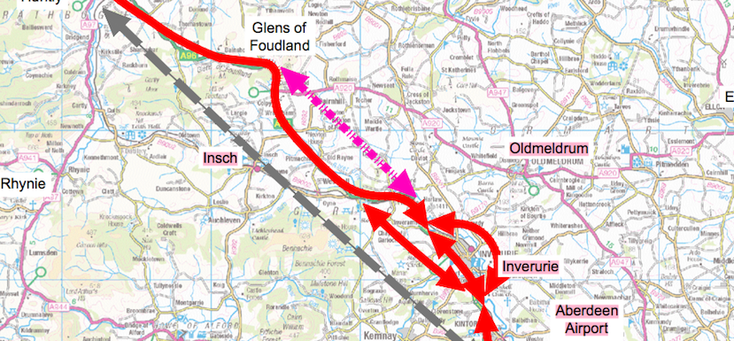
Extract from DMRB Stage 1 Assessment Report. Transport Scotland May 2015
Option B
Existing A96 Corridor with offline bypasses The principle of this improvement strategy option is an upgrade generally located along the route of the existing A96 corridor, with the exception of offline bypasses of settlements along the existing A96.
3.4.10 Section B9: Old Rayne to Kintore
Option B considers three potential strategies for bypassing Inverurie, comprising an upgrade to the existing Inverurie bypass and offline bypasses to the north or south of the town.
a) Inverurie Bypass (Inner)
The Inverurie Bypass (Inner) strategy comprises the existing A96 corridor Old Rayne to Kintore including the existing Inverurie Bypass. The A96 in this section is a single carriageway cross section between Old Rayne and Port Elphinstone Roundabout south of Inverurie where the A96 continues as dual carriageway. At Pitcaple, to the north-west of Inverurie, the existing single carriageway is constrained by the Aberdeen to Inverness Railway Line, which runs parallel to the A96, as well as roadside developments and the River Urie. At Inveramsay, the railway crosses over the A96 on a masonry arch bridge which has a 4.4m height restriction and the traffic under the structure is restricted to a single lane controlled by traffic signals, due to the arch and span of the bridge. The replacement of this structure is currently planned under the A96 Inveramsay Bridge Improvement project (refer to Section 1.7). The proposed bridge and road realignment is a single carriageway scheme.
The existing Inverurie Bypass is constrained along the north-east boundary by the residential and commercial properties of Inverurie and Port Elphinstone. In addition, the south-west boundary of the A96 is constrained with residential developments and a golf club at Inverurie. An existing local road overbridge crosses over the Inverurie Bypass on a three span structure which constrains the road cross section due to the leaf piers adjacent to the road.
The A96 crosses the River Don and its floodplain on a 140m long 4-span bridge. The primary junctions along the single carriageway include the B9002 and B9170. In addition, the dual carriageway section of the A96 includes two at-grade roundabouts with the B993 and a local road at Thainstone as well as two left in/left out simple T-junction at Clovenstone and Kintore Business Park. In addition, to these junctions, the existing dual carriageway section contains a left in/left out direct access and a left in/left out field access, both of which are located between the Port Elphinstone Roundabout south of Inverurie and Thainstone Roundabout.
(b) Inverurie Bypass (North)
The strategy for the proposed bypass to the north of Inverurie crosses the River Urie and the River Don and their associated floodplains as well as the Aberdeen to Inverness Railway Line.
In addition to the floodplains, the environmental constraints to the north of Inverurie include a scheduled monument (a Roman temporary camp) at Durno to the northwest of Inverurie, Harlaw Battlefield to the north of Inverurie as well as Keith Hall Designed Landscape to the east.
The primary roads to the north of Inverurie are the B9001, B9170 and B993.
(c) Inverurie Bypass (South)
The southern strategy at Inverurie would also cross the River Don and its floodplain, albeit the floodplain is narrower in this section of the river compared to the northern strategy. The topography to the south of Inverurie is undulating with numerous hills and valleys as the land starts to rise towards to Bennachie Mountains to the west of Inverurie.
The southern strategy would likely cross the Aberdeen to Inverness Railway Line near the north-western extent of the strategy. In addition, two SSE high voltage overhead transmission lines run approximately parallel in a north-west to south-east direction.
The primary roads to the south of Inverurie are the B9002 and B993.
Option C:
Offline from Huntly to Blackburn
This option was developed, irrespective of any constraints, to provide a more direct line from Huntly to Blackburn, bypass Inverurie to the south and avoid a number of sections of poor road alignment on the existing A96.
3.5.1 Option C
Option C is a fully offline alternative to the Option B strategy between Huntly and Blackburn. The option would likely tie-into the existing A96 between Huntly and the Glens of Foudland at the northern extent and between Blackburn and Kintore on the existing dual carriageway at the southern extent of the strategy.
The topography is the primary constraint for this strategy due to the undulating topography with high spots at Winds Eye (314mAOD), Wishach Hill (419mAOD) and the Hill of Foudland (467mAOD). The Bennachie Mountains (528mAOD) are located to the west of Inverurie. The strategy would likely have to pass in the gap between Wishach Hill and the Hill of Foudland. In addition, the strategy would require structures to cross the River Don, River Bogie, and a number of smaller watercourses as well as the Aberdeen to Inverness Railway Line near Insch.
Option D
Offline from Glens of Foudland to north-west of Inverurie This option was developed to provide a more direct line between a section of the A96 from the Glens of Foudland to north-west of Inverurie.
3.5.2 Option D
Option D is a fully offline alternative to the Option B strategy between the Glens of Foudland and Pitcaple. This strategy could be delivered in combination with either the Inverurie Bypass (Inner) or Inverurie Bypass (Northern) Option B strategies.
Depending on which strategy Option D is combined with, a bridge may be required to cross the River Urie. Two SSE high voltage overhead transmission lines run through the area in an approximately north to south direction and a north-west to south-east direction.
Environmental constraints within this section include two GDL designations at Williamston House and Newton House as well as a scheduled monument (a Roman temporary camp) at Durno.
The main local roads within this corridor are the A920 and B992.